Latest update April 17th, 2024 12:59 AM


Latest News
- Guyanese gain US$1.5B in contracts from ExxonMobil in 9 years
- Local investors enjoying same benefits granted to foreign companies – Local Content Summit hears
- Stop the world for Gaza: Pro-Palestinian protesters disrupt traffic at Golden Gate Bridge, O’Hare airport and other sites across US
- School girls penalised for bullying schoolmate
- Cop to stand trial for murder of Quindon Bacchus
As waters continue to recede…Heavy rainfall expected from today to Wednesday
Just as the flood waters have begun to recede, the National Weather Watch Centre (NWWC)
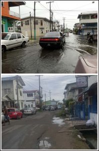
(Above): A section of Ketley Street, Charlestown on Friday.
(Below): Ketley Street yesterday.
has reported that heavy rainfall is expected from today through Wednesday with the development of the Inter Tropical Convergence Zone (ITCZ).
The ITCZ, is a belt of low pressure which circles the Earth generally near the equator where the trade winds of the Northern and Southern Hemispheres come together. It is characterised by convective activity which generates often vigorous thunderstorms over large areas.
According to the NWWC, the ITCZ is slowly but steadily developing over Guyana. The Centre is monitoring the situation which has developed along Guyana’s coast within the last 24 hours.
Associated weather
Coastal and inland Guyana are likely to experience periodic heavy downpours today during the early morning. Based on the current forecast outlook, flooding/water accumulation is likely to be observed in poor drainage, low laying and riverain areas.
The forecast models continue to show high moisture content in the atmosphere of which lies within favorable atmospheric environment for development of moderate to deep convective clouds, the Centre reported yesterday.
The forecasts favour generally overcast conditions with moderate to heavy rain for the morning into early afternoon, after which, a slow but gradual reduction in showers will be observed.
Extended Outlook
“These weather patterns and conditions will continue over the next few days (Monday through Wednesday) with the occasional heavy downpours, where another peak in rainfall is anticipated for Wednesday over areas in Regions Seven (Cuyuni/Mazaruni) to 10 (Upper Demerara/Upper Berbice) and some coastal areas in Regions Two (Pomeroon/Siparuni), Four (Demerara/Mahaica) and Five (Mahaica/Berbice).”
Possible effects of Weather
With the forecast weather conditions coupled with the high tides, coastal areas may experience prolonged water accumulations / flooding in poor drainage, low lying and riverain areas added to that of recent rains.
“In addition, please be advised that the next period of above normal High Tides will begin from Monday December 26, 2016.” The report stated.
The National Weather Watch Center says that it will continue to closely monitor this event and will issue bulletins as the need arises.
Meanwhile, after being affected by heavy rainfall which is attributed to flooding in several parts of the City, waters have already receded – which is a surprising development since in the past, waters would be stagnant for several days.
Bourda Market, which was described as one of the hard-hit areas on Friday, had recovered. Shoppers were seen carrying out their last-minute shopping unaffected by flood waters.
Similar Articles

THE BLUNT OF THE DAY

Sports


Features/Columnists
Bullying in schools

Kaieteur News – Every school teacher should take a close look at the students in his or her classroom. The probability... more
Embassy Raid Sparks Outcry: Urgent Healing Action Needed
By Sir Ronald Sanders Waterfalls Magazine – On April 10, the Permanent Council of the Organization of American States... more


Weekend Cartoon